切换至摄影模板
博文
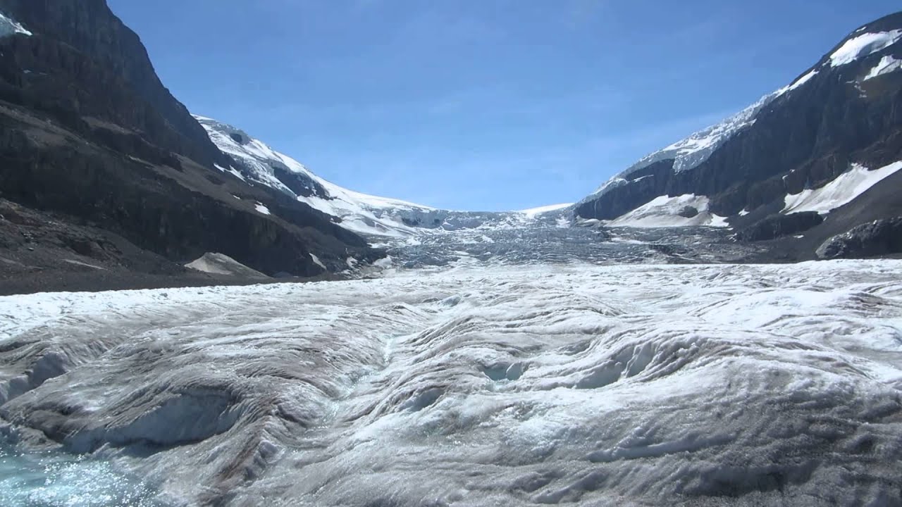
阿萨巴斯卡冰川
热度 4 |
横跨北美洲大陆分水岭的哥伦比亚冰源.位于加拿大落基山的93号公路西侧,面积约有125平方英里,厚度为330英尺至1198英尺,冰源四周共有Castleguard, Dome,Stutfield,Saskatchewan 等冰川,和现于公路边的阿萨巴斯卡冰川,这是当局唯一开放给游客拜访的冰川.游客中心设于93号公路右侧山坡上.停车场有冰川巴士载客上冰川观看冰源服务,收费约4至50元吧,(不清楚)巴士运客服务在冬季,夏季停业,游客除沿这小道正面登冰川外,也可沿巴士公路从冰川左侧的山腰旁进入冰川,再一条路在Wilcox pass Trail 步道上,步行上山,从高处拍冰川景,这条步道在Wilcox Creek Campgound 营地旁.

阿萨巴斯卡冰川远景,小虫头顶上的远处泊车区就是登冰川正面步道,左侧半山腰有一条冰川巴士路.

1925年标示牌,即1925年冰川边缘在这.已明显告诉我们,冰川在向后退缩,正在消融之中.

1982年,冰川已退至山坡上,

走向冰川,仍要向上慢慢爬行.

1992年,冰川已退到坡顶上了.

此时,已踏足冰川面上,左侧是年头冰川巴士走过的冰路痕迹,破坏冰川环镜的凶手,是人类.

千年冰川,深厚千尺.

这些雪糕筒,是当局注明不准超越的警告,理据是冰川有裂缝,深达十几尺,掉下危险.
免责声明:本文中使用的图片均由博主自行发布,与本网无关,如有侵权,请联系博主进行删除。


发表评论 评论 (3 个评论)
- 回复 雷公
- 夏,秋,才是游客取假较喜欢之季节,(冬季才去的多是本地人)尽管在夏天,太阳高照,行车还开冷气,但当你踏进冰川边缘,寒气巳开始迫人,上到冰川顶,就更冻.如你停的时间在30分钟左右,身体壮,可不用再带厚点衣服上去,(太座就冷到发抖)上与下,温差估计有十几度,.....冰川在盛夏时,急速溶化,裂缝就因溶化而成,这冰川够厚,我低头看裂缝,浅的地方在流着冰水,深的地方,见不到底.
曾经湘桥: 祝你阖家新春佳节快乐!
请帮解释关于当地冰川地带与其实际天气温度体现的现象有什么特别。比如说游客几乎都着装秋夏状态,为什么? ...
- 回复 liushuai2009
- 分享